


Monse 1 Voting District, Okanogan County, Washington
About
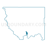
Outline

Summary
| Unique Area Identifier | 687783 |
| Name | Monse 1 Voting District |
| County | Okanogan County |
| State | Washington |
| Area (square miles) | 17.08 |
| Land Area (square miles) | 16.65 |
| Water Area (square miles) | 0.43 |
| % of Land Area | 97.49 |
| % of Water Area | 2.51 |
| Latitude of the Internal Point | 48.16102900 |
| Longtitude of the Internal Point | -119.69848690 |
Maps


Graphs
Select a template below for downloading or customizing gragh for Monse 1 Voting District, Okanogan County, Washington


Neighbors
Neighoring Voting District (by Name) Neighboring Voting District on the Map
- Brewster Flat Voting District, Okanogan County, WA
- Chiliwist Voting District, Okanogan County, WA
- Eastside Voting District, Okanogan County, WA
- Monse 2 Voting District, Okanogan County, WA
- Monse 3 Voting District, Okanogan County, WA
- Valley Voting District, Okanogan County, WA
Top 10 Neighboring County Subdivision (by Population) Neighboring County Subdivision on the Map
- Colville Reservation CCD, Okanogan County, WA (5,954)
- Brewster-Wakefield CCD, Okanogan County, WA (4,930)